Isle of Wight map
1864 Confederate map of Isle of Wight and part of Nansemond (nice find by Jerry Jolly)
https://www.loc.gov/resource/g3883i.la001283/
………………………………………………………………..
Some recent revisions… 1674 or so was the period when the “headright” system began to end. My idea here is to focus on those early patents… it is still a work in progress. (I find numerous patents still citing headrights until at least 1699… the 1674 date is simply a focus point)
http://genealogytrails.com/vir/isleofwight/land_grants_1628_1674.html
A few examples of the difficulty of creating this map…
Edward Brantley patent…IOW 1667 and 1669
Bond… John Bond… and Thomas Harris… and others in IOW
Nobody knows the trubble I’ve seen…
Christopher Reynolds land… IOW

I made this map several years ago and recently re-read it again.. anew, so to speak. None of it will make much sense unless you are researching people from the 17th and 18th century and actually dig into the dirt. . The “Indian Creek” I discuss does not exist in any modern accounts… it is a ghost record and can only be seen in a comprehensive map of the actual patents from “back in the day”.
Click image to open in another window to zoom in…(use Ctrl + or- to zoom more if you wish…)
Below is a USGS map surveyed in 1918… this shows the Indian Creek and Western Branch rivers before they were expanded to reservoirs in (I think) 1962. Of note is “Exchange Creek” which is now under water and previously known as “Indian Creek”. There was a mill pond and evidently it was navigable to that point. (Note the “wharf” by the pond). I hazard a guess that this area may have been a central point for a tobacco warehouse and shipping point with access to the Nansemond River. Also of interest is Reid’s Ferry at the point where the modern dam is located (this evidently was the principal road from say Chuckatuck to Suffolk. The area above Reid’s Ferry was the historical stomping grounds of the Nansemond Indians and Dumpling Island to the east (mentioned in early patents). I’m collecting notes and may take a stab at the early patents of Percival Champion and others. (His land can be pinpointed because he left a bequest to the “Glebe Church” in 1642 or so… the 2nd or 3rd incarnation of that church and the glebe land still exist across the Nansemond River). Below is the earliest record I have found for the area known as Indian Creek in IOW. (map is dated about 1670 – see under word “Nantemond”)

http://www.glebechurch.org/GlebeHistory1.htm
http://glebechurch.org/Glebe_Photos.htm
Regarding Nansemond- I recently found this map which refers to some very early patents in that area. It was finished in 1948. I note that the author deals with many of the problems I also face with my maps. Read his notes and see what I mean. He was cognizant that creeks may dry up, change course, shorelines may erode, etc. He addresses “foggy” patents by leaving them out. I am not demeaning his work by any means but simply, and sympathetically, sharing his frustration… I am sure that he would have been beside himself with the internet assets available to us new guys today.
https://www.loc.gov/item/2012589217/
https://www.loc.gov/item/2012589218/
Sketch Book of Suffolk County written in 1886…
https://archive.org/details/sketchbookofsuff00poll

Below are patents I have attempted to locate… there is a lot of guesswork, so don’t be too upset if I misplace your ancestor. The written patents can be found at the Library of Virginia website.
This file is huge… so be patient for it to load… (click once and then once more for the behemoth).

Of interest to me lately is the PITT line of IOW… below are some misc notes:
Where the hell was New Town Haven River?
According to Boddie: “Pagan River was probably so called because the Indian village, Mokete, was located on the south side of the river. The river was originally called Warrascoyack and afterwards New Town Haven and then later on received its present name.
There are 2 histories written for Isle of Wight that I consult.
A History of Isle of Wight County: Written about 1907 by Col. E. M. Morrison for the Jamestown Tercentenary Exposition.
County Sketch and Historical Records: From the William and Mary College Quarterly Historical Magazine (April 1899)
http://www.usgwarchives.net/special/wmmaryqtr/vol7-4.htm
The 1907 Morrison account is my favorite to figure out “places” such as creeks.
http://tdcweb.com/tdfhs/histories/islewight/islewight3.htm
“In the year 1634 the colony was divided into eight shires or counties, one of which was named Worrosquoyacke, afterwards Isle of Wight. The government of these shires or counties was modeled upon that in England. Lieutenant Colonels were appointed and commanded the troops in the wars with the Indians. Sheriffs, sergeants and bailiffs were elected; and, until 1691, every freeman was entitled to a vote, and indentured servants, at the expiration of their term of service, were allowed to do the same. In 1628-29 commissioners were appointed and required to hold monthly meetings in the different shires or counties; hence, the origin of the county courts.
The original boundaries of the county of Worrosquoyacke, or Isle of Wight, were: Northerly, by Lawnes Creek; Easterly, by James River as far as the plantation of Richard Hayes, formerly John Howard’s; the southern boundary by certain creeks to the head of Colonel Pitt’s Creek (this proved somewhat uncertain); and westerly into the woods indefinitely. In 1656, upon the petition of the inhabitants of Ragged Island and Terascoe Neck, then in Nansemond county, they were put into Isle of Wight.
A long dispute arose between the counties of Isle of Wight and Nansemond, continuing until 1674, when, by an Act of the General Assembly (then called the House of Burgesses), the boundaries were established as they now are, viz.:
“That a southwest by south line be designed, runned and plainly marked from the river side of the plantation of Hayes, extending to the creek at or near the plantation called Nevill Oyster Bank; thence a line or lines up Col. Pitt’s creek to the head of his lands; thence in a southwest half a point westerly line “
———————-
In the case of the PITTs, there was more going on than is apparent merely by the original patents… that is, horse trading…
JAMES ROCHE TO HENRY PITT, assignment of land lying in Chuckatuck, sold to Roche by Thomas Brice 14 Jane 1643, this 10 day June, 1647. Teste, George Fawdon, Anthony Jones, Thomas Wombrell, clerk of court.
JAMES WATSON, tanner, and Mary his wife, they moving sell to Henry Pitt 200acres part of John Sparkes pat. of 750 acres and sold by said Sparks to Peter Hull and by Hull to my brother Robert Watson, adjoins the land of Anthony Jones where my brother Watson formerly lived and now the said Henry Pitt. 10 March 1655. Teste, Thomas Woodward.
RICHARD (R. Y.) YOUNG sells to Robert Pitt, merchant his patent of 350 acres upon New Town Haven Creek Between the land of Richard Preston and Thomas Jordan and also hath sold 100 acres patented 24 Aug. 1648 now in tenure of William Denson and John Oldis. For 1500 lbs. tbco. 5 Feb. 1649. Teste, Robert Gaylord, Robert Pitt, Jr.
Windsor castle
http://en.wikipedia.org/wiki/Windsor_Castle_(Smithfield,_Virginia)
——————
A study of some Pitts…
First a head scratcher I recently found. My note in the blue area below states that John Pitt in 1702 gave to his son Henry Pitt “all that 1200 acres of land that his father Col Robert Pitt lived on” (paraphrased).
But it seems that Hugh Campbell in 1698/9 purchased the 1200 acres. I’ve analyzed the metes and bounds and there is no doubt it was the same land. I am dumbfounded. I mean, what the hell?
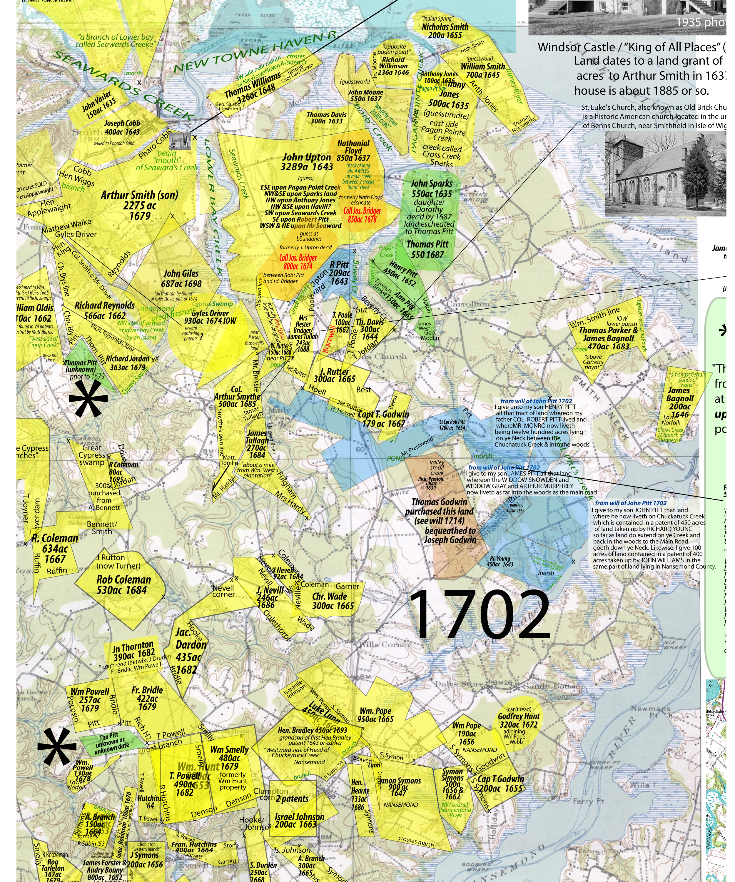


I hazard a guess that if you follow the above directions… whip out a metal detector and happen to find a spoon or some such … well, you get my drift.
John Seaward and son were interesting…they are all over the map, so to speak; just above the town of Smithfield when it was still New Town “haven” and somehow also near the Pitt and Bridger properties… I had some fun with this post:
Walking the Bog…
Note to commenter… Israel Joiner, 1719. I “think” this is where he was but need more clues to be sure.
I guess I’m going to have to look at all your entries.
My forefathers came to America in 1636 and settled in Accomack Co., Va. Later, the Parnell’s, Colson’s, Smith’s, and Cooper’s moved to Isle of White before traveling further west. I noticed that George Anderson’s patent is not far from where the Parnell’s and Smith’s lived.
Jacob Colson lived in Isle of Wight with his two sons – Abraham and Joseph. Joseph Colson later moved to Plumtree Island in 1721. Both J. Colson and J. Calvert bought land on Plumtree Island on the same day. His brother Abraham Colson was a registered Chickasaw Indian trader and traded with my Joseph Calvert and later James Logan Colbert. James was Joseph’s son. James had a twin brother named Thomas. I’m a descendant of Thomas. He settled in Franklin Co., NC with the Parnell’s, Cooper’s, Smith’s, Williams’, and Bibby’s. All these families originiated in Accomack and Northampton counties in the mid-1600’s. Capt. William Bibby was the person who transported by 7th great-grandfather, Christopher Calvert, to Accomack Co in 1636.
Richard A. Colbert
Richard A. Colbert
December 21, 2010 at 3:40 pm
I have some new patents for the IOW map that I will update when I get a chance… if you have some specifics of Colson/Calvert aquisitions in the area let me know …
anderson1951
December 21, 2010 at 4:14 pm
Anderson1951, I need to get in touch with you, could you please email me asap at publisher@americandigger.com? Thanks!
Butch Holcombe American Digger Magazine
May 28, 2017 at 3:02 am
Marc, I have a group of Boyt, Ballard, Langston researchers who would like assistance adding a few patents next to some you have already done in Nansemond near Somerton. Do you do that type of work or can you recommend someone who can? Thanks davidboyett AT aol.com
David Boyett
April 30, 2021 at 8:08 pm
This is a reply to your entire body of work. I use the Internet extensively for genealogical (and thus historical) work. It is a joy to find such a wealth of information that is well researched and presented. I thought I knew a lot about southside Virginia and early North Carolina but I bow to your expertise.
I have no Andersons in my lines but that does not matter. We overlap and the migration patterns are the same.
Thank you for this incredible site.
Jane
July 16, 2011 at 6:11 pm
Thank you Jane… You made my day.
Marc
anderson1951
July 16, 2011 at 6:27 pm
I am a descendant of Frederick Anderson who served in the 3rd Regiment Continental SC July 1779. He was in the 1790 census, surveyed land in 1784 and moved to GA MS, Amite Co.
Do you have any info on him such as siblings, parents, residence(Possibly Lancaster/Camden). He later married Abigail Maxfield in GA or SC.
Thank you for your loving research and for sharing it with us!
Lois
Lois
October 23, 2011 at 7:31 pm
Hi Lois
One Frederick I can think of was a son of Henry Anderson who left a will (Edgecombe) in 1801 (see under Pages). He apparently died prior to 1815.
DB 15-425 HENRY ANDERSON was son of HENRY ANDERSON, dec’d.; three brothers of said HENRY ANDERSON JUNR. were deceased, to wit, WILLIAM ANDERSON, ALLEN ANDERSON, and FREDERICK ANDERSON, Dec. 29, 1815.
———
After some further research, this Frederick was apparently a young child when he died by 1815… so this is likely not your guy. (marc)
anderson1951
October 24, 2011 at 3:33 am
Thank you Anderson 1951! I am just now getting back to this page. Firefox update was not working well and bumped me off before I could record.
This may be a break through for me. My Frederick Anderson did die in Amite CO MS in 1814. He had a brother named William. Do you have any additional info. I did find a will from Henry married to Charity stating Frederick as a son.
He was accepted at the SAR and I am trying to establish him with the DAR. I need to tie him to a residence or family around Camden District, Lancaster SC abt 1779, or a reason why he enlisted there.
Many thanks to you,
Lois
Lois
November 23, 2011 at 6:57 pm
What I have posted is about all I have… The Henry d.1801 seems to have first acquired property in Edgecombe around 1780 and nothing is known where he came from. My impression is that the son Frederick was under age at the time of his death but it could have been other children? Your lead may place the family as coming from SC and the time frame would work.
Marc
anderson1951
November 24, 2011 at 5:30 am
Outstanding work! Thank-you for including patents and deeds of folks other than the Andersons on your maps. I am a Howard descendent, tracing my colonial Howards back from Onslow County NC to Bertie/Chowan Cty NC to Nansemond Cty VA. Very near the southern part of your map where you have Thomas Howard, there also resided James Howard, some Fosters, and a few other families mentioned in the Va Cavaliers and Pioneers book. Your site and another site are the first ones that have pinpointed the location of “Kingsale”, again, thanks.
Mike
Mike Brown in Norfolk VA
January 18, 2012 at 11:32 am
Glad to help… I’m sure I have errors but most patents are in the “ballpark range” hopefully..
anderson1951
January 18, 2012 at 11:54 am
Thank you so much for adding the information about the Parker.
Wayne N. Parker researcher for Y-DNA Parker Family Group#7 P239
Wayne N. Parker
October 14, 2012 at 2:07 pm
My pleasure… good luck in your search…
anderson1951
October 14, 2012 at 4:13 pm
Hi,
I have your map page showing the Parker family land linked to my on-line working file. Some Parker researchers are getting the impressing that I did the maps. I just wanted to let you know that I all telling them that I did not do the maps.
Wayne N. Parker researcher for P239 of the Parker DNA Project Family #7.
Wayne N. Parker
September 28, 2015 at 11:13 am
Thanks Wayne… I don’t mind sharing. We are all playing the same game.
anderson1951
September 29, 2015 at 3:55 am
Anderson, my friend: It just occurred to be that you speculated that Bridget Lewis might be the widow of John Brown but Brown died in 1665 and his widow Bridgett was granted letters of administration on March 26, 1666, which means that she was clearly an adult in 1665. If Anthony Lewis was born in 1665 or thereabouts, one is left to wonder how this birth as a Lewis might have happened. If Anthony was an adult when George Cripps died in 1687, the latest he could have been born would be sometime in 1666. It seems unlikely that Bridgett Brown married a Lewis after John Brown’s death and then produced a son on that kind of schedule.
I think it far more likely that Bridget Lewis was Anthony’s sister and that Mary Skinner and Joyce England, two kindly sisters who may have known the father and/or mother, decided to take in the orphans as an act of kindness.
Bill L.
J. William Lewis
August 1, 2013 at 8:14 pm
Hi Bill
I see you are still wrestling with that dilemma…
http://andersonnc.wordpress.com/2013/05/11/anthony-lewis-a-pain-in-my-rear/
I theorize that Brigett Lewis may have married John Brown at a later date than you mention… he was still married to a woman named Mary in 1690. Both he and Bridget would be older when they wed… Perhaps she had a previous crop of kids as did John Brown also?
9 Aug 1706…. John Browne and wife, Bridgett Browne, to Samuel Canidy…. 220 acres (being a patent dated 29 Apr 1692 in the lower parish on the south side of Kingsale Swamp and bounded by Jonathan Robinson and William Stott (Scott?).
Wit: Richard Exum and William Murray.
John (X) Browne
Rec: 10 Jun 1706
(this John Browne is alive in 1707, from his deposition…aged 68. )
———
This John Brown removed to NC around 1700 and seems to die 1713. “A” Bridgett leaves some records there and also several other Lewis’ leave records… hence my theory.
This is perhaps my strongest lead…
Bridgett Brown, to my son Isaac Lewis. Power of attorney.
(no date but in 1713 range)
Who knows what records Hathaway was digging into- early Chowan or Bertie deeds I assume- but he is merely abstracting the records… was this Bridgett the widow of John Browne and if so, who was she? If so, she was possibly a former wife of _____ Lewis?
Deed Bk W #1, Chowan Co., NC, Hofmann
#321 pg. 154 BRIDGETT BROWN of Chowan Prect. to ISAAC LEWIS of ye Co. of Albemarle, my well beloved Son 15 July 1713 Letter of Attorney to prosecute to Judgement any person I, the sd. BRIDGETT BROWN, shall at this time or from time to time bring action against and likewise to Defend any action brought against me Wit. TREDDELL KEEFE, MARY LEWIS m her mark Reg. (not given)
That sure sounds like a nervous widow to me… no husband around so she turns to her son to act in her stead…
Here is the Browne thread…
http://andersonnc.wordpress.com/john-browne-of-kingsale-1639-1713-indian-trader/
———
If I am correct… when William Brown (son of John Brown) and Anthony Lewis (son of Bridgett) each get property around 1702-1706 in old Isle of Wight (now Southampton) then they may be step-brothers.
map here…
http://andersonnc.wordpress.com/some-surryiow-patents/
anderson1951
August 2, 2013 at 3:33 am
I want to thank you for the outstanding job with the patent maps that appear on this website. I’ve been looking high and low for these maps for Isle of WIght, Surry and Nansemond for quite a while, and these are the best I’ve come across, by far. Not sure what your source is, but I’d love to see more of these to help with my research in these 3 counties. Is there a more comprehensive source for these other than DeedMapper? Any info or leads you can provide would be very much appreciated.
Bill D.
Smithfield, VA
Bill Dancy
November 6, 2013 at 6:10 pm
Bill
These maps are all my own effort over several years… I’m a commercial artist by trade and a genealogist by wishful thinking. I started, as everyone does, wondering where my ancestors may have lived and simply got carried away. The result is these maps.
The Library of Virginia (online) is my primary source for the original patents… I draw them to a scale of 1″ = 1 mile to match the scale of the historical USGS maps (also online) and the rest is simply a jig saw puzzle.
Match the neighbors noted on the patents or other historical records which can be found to the “shape” of the patent and you have some remarkable bits of information… as you see.
I try be precise but you will note many “orphan” patents that do not have enough clues… so some are guesswork at this point… the more that are done, the more accurate the maps become.
Enjoy… and thanks for stopping by…
Marc
anderson1951
November 7, 2013 at 4:12 am
Thanks for the quick reply Marc. I’ve checked out the original patents on the Lib of Va website, but that old English writing is quite hard to follow. I know there are short abstracts for these in “Cavaliers and Pioneers”, but I’ve never been able to locate full “translations” anywhere. Have you had any luck with that? I also frequently use the historical topo maps as well as older ones including the Gilmer maps of the Civil War era. But it seems like colonial maps of this area are pretty much non-existent, especially ones that show details like individual homesites, roads, etc. I’ve found a couple for the Hampton and Williamsburg areas, but nothing south of the James. Anyway, just wanted to let you know again that I really appreciate all the hard work its taken to put together not just the patent maps but all the other documentation that’s available on your website. And oh, have you ever tried or had any success with the DeedMapper software for mapping patents? Thanks again and take care ….. Bill
Bill Dancy
November 7, 2013 at 7:10 am
Marc- it’s been quite a while since our last communication, but I have a small request. I’ve been working on an educational book for a couple of years now about colonial artifacts from Virginia. I have a small section in one of the chapters about land patents, and I was wondering if you’d be willing to grant me permission to crop a small section from one of your “yellow” land patents maps to serve as an example which would greatly help the reader to understand what this concept is all about. If you’re OK with this, I can include a credit as to where the map came from. If so, how would you like it to read? Like I mentioned a while back, I think you did a great job with these maps and they’ve been an invaluable resource to me in my research. It would be a privilege to include one of these in my book. BTW – the small section of map that I was wanting to use (from Surry County, VA) shows a small 1643 patent, and after getting permission from the current property owner I was able to locate the original house site along with some 17th century artifacts which validated the accuracy of your maps. Thank you and take care …. Bill Dancy / Smithfield, VA
Bill
By all means use any references you feel useful…
I find it fascinating you tracked down an original house site! Please send a cite for your book, I would like to read it.
Marc Anderson
Bill Dancy
May 27, 2017 at 7:04 pm
Hey Marc – I thought I’d touch based again since you asked me to contact you when my major new book was complete. Well it’s done and I have several hundred printed copies here at the house now. The title is “Discovering Virginia’s Colonial Artifacts – A Comprehensive Guide to Recovery, Identification and Preservation”. It has an awesome hardcover and is nearly 400 pages long with almost 1000 color photos. It’s also printed on high quality, glossy stock which really enhances the photo quality. If you want more info on the book, or are interested in ordering a signed copy, you can contact me at bdancy97@charter.net. And thanks again for letting me use one of your patent maps (which you’ve been credited for in the book). Hope to hear from you soon …. Bill
Bil Dancy
October 12, 2017 at 11:38 am
The olde writing is tough but the more you do the easier it gets… (I just muddle through). The software I use to plat the patents is called Metes & Bounds, by Sandy Knoll software (about $30).
I think any early maps are long gone… as I understand it, the surveyors had personal maps but were loathe to share them with others (why give competitors an edge?).
anderson1951
November 8, 2013 at 5:30 am
I cannot wait to start digging in here more as I have Godwin ancestors, and I saw somewhere in my reading that Godwins and Milners were married back there. My best friend has Milner ancestors, so I would bet money we are distantly related. She has very little family history, but I have a notebook 3″ full of info, so I hope we can find the proof.
Ellen Gonzalez
December 29, 2013 at 11:02 am
Check out my Page for PITT (at bottom of list on right)
Don’t forget the SEARCH button under the Page list (I have Godwins all over the place)
anderson1951
December 29, 2013 at 11:11 am
Thanks for the reminder. I did use the search button and also some other googling and I believe I have found the common ancestor of my good friend and I: Elizabeth Godwin, daughter of Barnaby Godwin and a Miss Wilkerson (Wilkinson?) who married John Milner. This would make us about sixth or seventh cousins. Also a Mary Godwin married a John or Thomas Milner, so I am still not sure. I am from the Godwin line through my maternal grandmother, and she is from the Milner line through her paternal grandfather. Now just tying up all the loose threads and proving this as once again, so many similar names used over and over. My maternal grandfather was a Browne, which is how I came across this blog in the first place, and still do not have a straight line back to the first one here, though I think it was Dr. Samuel Browne.
Ellen Gonzalez
December 30, 2013 at 10:19 pm
Hi Marc, I saw your question re: where is NEW TOWN HAVEN RIVER & thought I would pass on to you if you still don’t have this: New Town Haven River was PAGAN CREEK in IOW in 1639…PAGAN’s Creek was not far south of Elizabeth River. The old COURT HOUSE was in Smithfield VA on the Pagan River / Creek. That is where “The Great Book” was rescued by the court clerk’s wife when she got word that the British were coming to burn the court house, and she took the Great Book and buried i a near by farm field. This is the Great Book now in the VA. Archives.
Lafayette River was earlier know as TANNER’s CREEK in NORFOLK Co., VA.
In the original shires in 1634 Tanner’s Creek was in Elizabeth River Shire and became Norfolk Shire in 1691.
SUMERTON CREEK was also known by the name BEAVERDAM SWAMP and in the Nansemond Co VA records Beaverdam Swamp was also called CYPRESS SWAMP.
There is also a map on the web-site of “The Watkins Family and the Society of Friends” and this map shows LAWNES CREEK in IOW & Nansemond VA., and the Quaker Meeting houses.
The ” Main” BLACKWATER was on Cypress Swamp. On a map of today, I saw Cypress Swamp located not far south of the City of Suffolk VA.
Hope this helps,
Cheryl
Cheryl Horne
January 13, 2014 at 7:08 pm
Also…..Smithfield, VA on Pagan River is right there on the James River. Smithfield VA where the old Court House was, is on present day HWY 258. I am wondering if the current Hwy 258 was “the old court house road” mentioned in early colonial Bertie/ NHCNC time frame deeds around Murphreesboro?? Today Hwy 258 runs south westerly from SMITHFIELD, VA. and goes through the town of FRANKLIN, VA. and through Woodland Twp NC and right to MURPHREESBORO, NC now in Hertford Co NC and was once in NHCNC before Hertford County was formed. As the crow flies, from Murphreesboro NC to Smithfield VA is only a little over 50 miles! Hwy 258 also continues southerly from Murphreesboro to Tarboro NC on the Tar River. A lot of the info I got was taken from LOWER NORFOLK CO VA ANTIQUARIES, on GOOGLE BOOKS digitized and found on-line at historybookcorner.com paid site. AWESOME BOOK! Also: BRIEF ABSTRACTS of LOWER NORFOLK COUNTY and NORFOLK COUNTY, WILLS, 1637-1710, 1914; reprint, Easley, South Carolina: Southern Historical Press, 1982, Digitized and available at FHL digitized version at GOOGLE BOOKS (full view).
Cheryl
Cheryl Horne
January 13, 2014 at 7:56 pm
In reply to some earlier posts, I actually did find that my Milner friend and I are related through the Godwins. I also have Bridgers and Pitts in the family tree, so no doubt all these were neighbors at one time. Back then who would your kids have married but the neighbor’s kids?I will have to spend some long hours going through all the above pages of notes with a fine toothed comb after I get all my info into the proper form, which at the moment is a notebook full of notes and sometimes I cannot read my own scribbles. Can anyone recommend a good online free program, as I refuse to pay for anything. Must be that thrifty Scots blood in my veins. BTW, this blog has encouraged me to do more online searching and I finally found the elusive Scottish grandparents, the ones who actually have provable birth dates and locations from Scotland, which I have been hunting for over 30 years.
elenalareina
January 13, 2014 at 8:25 pm
Mr. Anderson, I am working on a similar map project in regard to the William Boddie property that is pictured in your first map. I would like to collaborate and share information with you. I frequent the IOW area although I live about 5 hours away from it. Also I am working on a project regarding Granville and Vance counties in NC. Those two counties are connected with IOW because of immigration from IOW to both of them.
t.fuller
July 13, 2015 at 6:22 pm
Great work on your maps! Looks like you put a lot of work into it. My ancestor John Duke was neighbor in 1667 to Jeremy Rutter and was able to locate on your map. He died and his son sold the 50 acres of land he had bought from the 300 acres of Jeremy Rutter. Then the son moved 5 or 6 miles to the west and bought land adj. William Body/Bodie then later bought 150 acres from him close to Cyprus Swamp which I was also able to find on your map. Thanks for your work helping me to visualize where on the map my ancestors lived.
Steven Mangum/Duke
January 16, 2016 at 11:22 am
Marc..where do you get the maps? I looked on USGS but can’t find this one. Thanks again.
Jerry
jollyofva
July 10, 2016 at 2:01 pm
interesting site…
http://www.oldmapsonline.org/en/Rocky_Mount#bbox=-77.86236299999996,35.787346,-77.36248500277708,35.968165&q=&date_from=0&date_to=9999&scale_from=&scale_to=
USGS (site for the oldest historical maps)
http://store.usgs.gov/b2c_usgs/usgs/maplocator/(ctype=areaDetails&xcm=r3standardpitrex_prd&carea=%24ROOT&layout=6_1_61_48&uiarea=2)/.do
You have to piece these smaller maps together to get larger maps that I use…
anderson1951
July 11, 2016 at 3:10 am
Fantastic work! I have ancestors from several lines who lived in this part of Virginia. I’ve found some in your maps, and it’s so wonderful to see the actual locations where folks lived. I’ve found Thomas and William Powell, Thomas Harris, and William Yarrat. Thanks so much!….In your research, have you found where the Beaverdam Branch of the Nansemond River might be located?
Dee
March 11, 2017 at 2:28 pm
“beaverdam” was a common name used… there may have been several. I used the search term “beaverdam nansemond” (words anywhere) option and came up with two references…
example
Richard. grantee.
Land grant 15 October 1698.
Summary Location: Nansemond County.
Description: 50 acres on the southeastward side of a swamp called the Beaverdam Swamp; adjoining the land of John Copeland &c.
Source: Land Office Patents No. 9, 1697-1706
So I think your best bet would be to associate the surrounding landowners to fix a location.
With that said though… here is a Civil Ward map showing Beaverdam R. coming directly off Nansemond River (look just below Suffolk)
https://www.loc.gov/resource/g3883i.la001283/
But also note another Beaverdam Swamp a few miles to the east…
Marc
anderson1951
March 12, 2017 at 5:11 am
Marc,
These maps are fantastic! I am a descendant of John Newman, Thomas Taberer, Joseph Bridger and a few other Isle of Wight residents. I am trying to figure out where John Newman’s (NUMAN) land was located. He married Ruth (daughter of Thomas) Taberer and in his will of 11 Dec 1695 he described the land as “Cookes Quarters” adjoining John Screws being accounted one hundred twenty five acres more or less as its bounded. Seems like it is the Newman property referred to in the Woodard property. There is also a William Newman (cousin or brother) in Isle of Wight at the same time. Any help / advice would be appreciated.
John
John Taylor
January 1, 2018 at 1:20 pm
see this patent (Library of Virginia online patents)
URL (Click on link) http://image.lva.virginia.gov/cgi-bin/GetLONN.pl?first=87&last=&g_p=P8&collection=LO Patent
Author LinkMizle[Meazell], Luke. grantee.
Title LinkLand grant 23 October 1690.
Summary Location: Surry County.
Description: 150 acres according to the most ancient and lawful bounds. The said land being formerly John Newmans and was lately found to escheat.
Source: Land Office Patents No. 8, 1689-1695, p. 87 (Reel 8).
Part of the index to the recorded copies of patents for land issued by the Secretary of the Colony serving as the colonial Land Office. The collection is housed in the Archives at the Library of Virginia.
Other Format Available on microfilm. Virginia State Land Office. Patents 1-42, reels 1-41.
Subject – Personal LinkMizle[Meazell], Luke. grantee.
LinkNewman, John.
It would seem to be Surry County… perhaps near the IOW boundary as you suspect.
See this map… you may pick up a clue (I don’t see your guy but maybe you can find a neighbor)
https://andersonnc.wordpress.com/2016/12/04/edward-brantley-patent-iow-1667-and-1669/
anderson1951
January 1, 2018 at 1:45 pm
Marc,
Thanks for the pointers! I have looked around to see if I could find another reference to “Cookes Quarters” and so far it is only in his will. Do you know what they meant when they used the word “Quarters”? Time for more study.
John
John Taylor
January 2, 2018 at 9:19 am
I’ve noticed sometimes “quarters” in this 1600s time period referred to where Indian traders met and exchanged skins and other trade goods… but I would be hesitant to consider that in this case.
Perhaps a “work zone” … I think Tanners or Coopers, etc might work in this case???
Another possibility is “servants quarters”… I’m grasping at straws here (smiling)
https://www.encyclopediavirginia.org/Indentured_Servants_in_Colonial_Virginia
anderson1951
January 2, 2018 at 10:15 am
Hello, stumbled upon your page by accident as I was searching for the names mentioned in Dr Samuel Browne’s last will and testament. I re-started our research from 25 years ago and find myself on rabbit trails a lot, lol. The info you provide and also your theories are quite entertaining and draw me in.
Most of the ancestors I am researching, on both sides of the fam, lied in Northampton County, NC. Which includes much of Dr Samuel’s NC grant land. Our line follows his son Walter’s descendants. Lots of info thru the Quaker Gen books.
Have you made a connection to England and where Dr Samuel came from? I am not sure if ancestry.com info and the copy and past stuff there is just another rabbit trail. Was his father’s name Edward?
What’s interesting is people from the maternal side (Rhone) a ways back had purchased land originally owned by the Browns (John and Walter). In 1901 the 2 families connected with a marriage. Fascinating!
Micky Brown
January 11, 2019 at 1:34 pm
Hi Micky
I have only slightly addressed Dr Samuel Brown in my study of the John Brown family (I call him the Indian Trader). I do however feel confident I have him mapped out somewhat in the Virginia side of the Meherrin River area.
Use my “search” button for “dr samuel brown”… I have some info…
Good hunting!
Marc
anderson1951
January 11, 2019 at 11:36 pm
The “Thorn” in my side is the John Thornton on your plat map if IOW. For your records (you may already have).
What is known from the will of John Thornton, signed April 3, 1687, is that his “loving” wife is Willmuth, and their two children are William and Ellinor whom are not yet of age, and Willmuth had two sons from a previous marriage: Richard and Robert. The last name of Richard and Robert is not certain due to its appearance. However, another document gives credibility to the last name as Glinn.
[There are certain (if not all) family trees that purport that the sons of Willmuth are of the last name Symms/Sims. This likely came about from the excerpt of Virginia wills whereas it is written, “Richard and Robert Sims (?).” The question mark seems to have been ignored.]
The last name of Richard and Robert (stepsons of John Thornton) was not clear in the will. An indenture on 21 Jan 1723 between Richard Glinn and William Thornton describe a “certain tract or parcel of land in the lower parish of Isle of Wight County being a patent granted unto John Thornton bearing Date the 20th of April 1682 by estimation containing 190 acres given by John Thornton by his last will & testament unto the aforesaid Richard Glinn & Robert Glinn whom the said Richard survived.” (FHL Film 007645141, image 324/492; Deeds and wills Vol. 2(2nd vol.) 1715-1726).
In a nutshell,
• John Thornton married the widow Willmuth who had two sons Richard and Robert Glinn.
• 1682 John Thornton granted land in IOW.
• 1687 John Thornton is sick and dead by April 1688: leaving his wife Willmuth, his son and daughter William and Ellinor Thornton, and two stepsons.
• Robert Glinn dies between April 1688 and 1723,
• William Thornton is married to “Elizabeth” before Dec 1723.
Thank you for all that you share,
J. Thornton
Jennifer Thornton
November 21, 2020 at 11:44 am
Thank you for all your hard work putting this map together. It’s a fantastic asset for anyone that is researching early IOW!
My ancestor is James Hawley whose 300 acres you have placed in the James River just north of “The Rock.” I can only assume you put it there because you couldn’t determine where his land was located. Based on my research, I believe his land was most likely located near the Ambrose Bennett tract.
“Cavaliers and Pioneers” on Ancestry provides the following records for James Hawley’s original patent and his two renewals of that patent:
Patent Book No. 1, Part II, Page 125
JAMES HAWLEY, 300 acs. Isle of Wight Co., Apr. 22, 1641, p. 748. Upon the head of the Lower Baye Cr., adj. John Rowe. Due for the per. Adv. of himself, Ann, his wife, & trans. of 4 pers: francis Ann & Alice, his children, John Foster & Richard Darling. Patent renewed Sep. 27, 1643.
Jame’s patent clearly state’s that his land was “upon the head of Lower Baye cre. adj. John Rowe” whose patent appears on the same page:
JOHN ROE, 150 acs. Isle of Wight Co. This patent purchased by Mr. Arthur Smith & renewed in his name Mar. 2, 1643. (Incomplete). P. 745
And, whose name do we find on that same page?
AMBROSE BENNETT, 1,150 acs. Isle of Wight Co., June 23, 1641, P. 746. Upon the maine head of the Lower baye Cr. called Cypress Swamp. Trans. of 23 servants …
Thus, it seems to me that the Hawley and Rowe lands were situated somewhere in the vicinity of the land owned by Ambrose Bennett.
Let me know what you think.
-Kathi
Kathi Jacobs
July 23, 2021 at 12:56 pm
Hi Kathi
You are correct… I did not have enough puzzle pieces to “place” your guy. So I just left him floating in the water… very untidy of me. I just did a quick search with the new search button and up pops numerous patents for your James Hawley… I would dig in but am otherwise involved with other projects…
Good hunting tho’… enjoy…
https://lva.primo.exlibrisgroup.com/discovery/search?query=any,contains,james%20hawley&tab=Digital&search_scope=DIG_SP&vid=01LVA_INST:01LVA&facet=lds04,include,Lan&lang=en&offset=0
anderson1951
July 23, 2021 at 5:08 pm
First and foremost, thank you for all your research and mapping work. I can’t tell you how often as a researcher that I’ve looked at your work and it’s just all made sense.
I’m about to embark on a similar mapping project for just north of the James River and probably going to start with historic Henrico Co where a good portion of my ancestors lived. Do you have any tips or tricks for charting (re-charting, moving, modifying) as you work through all that written information?
Michele Jackson
August 28, 2021 at 9:35 am
Hi Michele… thanks
Affinity Designer https://www.youtube.com/watch?v=KzVxyq9uIKQ
Metes and Bounds by Sandy Knoll https://www.youtube.com/watch?v=R-gFW7a6RcQ
USGS historical topo maps (for background base map) https://store.usgs.gov/map-locator
I prefer an iMac 27 inch… a large screen is almost required…
email if you are serious…
marcanderson1951@gmail.com
anderson1951
August 28, 2021 at 10:39 am
I just wanted to tell you how much I love these maps!!! I look at them everyday to answer different questions. Thank you for sharing them. I wanted to ask specifically about the Map on Chowan Precinct. I’m looking for the land grant given to Israel Joyner on Cypress Swamp in 1719. He patented 640 acres in Chowan Precinct on the south side of Meherrin River. When he sold it, the land was referred to as, “On SS Meherring River at mouth of Cypress Swamp”. I have noticed there are several Cypress Swamps and just wondered if you’ve worked with this particular patent yet and if you know where it is
? Thanks again for all that you do!!
Bliss Joyner Kaye
March 18, 2022 at 5:20 pm
I have him on a map I have not published yet… need more puzzle pieces to be sure. I will add to bottom of this Page.
Just click on the filename…
anderson1951
March 19, 2022 at 2:29 am
It’s good to know you’ve located the land where he lived. I’ll look forward to seeing it. Thanks again!
Bliss Joyner Kaye
March 19, 2022 at 5:19 pm
Thank you so much!! Great to visualize where it was. Interesting that I’ve identified a Turner connection in my DNA analysis. I will definitely see if there is a possibility that they descend from Israel’s neighbors. I have some female brickwalls on my Joiner line. Thank you Thank you!! This is very helpful.
Bliss Joyner Kaye
March 20, 2022 at 3:49 pm
Hello Anderson51,
I am from the Isle of Wight County Historical Society. More than 15 years ago I contacted Dennis Hutchins, former Surry Co Clerk of Court, who sent his floppy disc/CDRom with an extraordinarily researched and plotted map of reconstructed 17th and early 18th century IoWC patents . Did you know Dennis, get his CDRom, and explore his research which may still may be available on an old computer in the back room of the Surry Co Historical Society.
We are establishing both physical and digital archives of all old local private documents in the IoWC Old Clerk’s Office to complement the public archives in the Courthouse. We greatly respect your research and would be very interested in your visiting us sometime in the next months, perhaps for a seminar on the earliest archival map research. Could you possibly directly email to me your own direct email so that that we could explore the possibility of such a visit ?
williamvgarner
August 7, 2024 at 4:48 pm
Hello Anderson51, we’ve communicated before about Israel Joyner’s land grant on Cypress Swamp. I am in the middle of writing a Kinship Determination Report on my Joyner line, and wanted to ask if it would be ok if I used some screen shots of your land plat maps showing the land of my Joyner ancestors? I will credit you in the citations. Thank you for your consideration.
Bliss Kaye
December 27, 2025 at 9:03 am
Sure, it is ok to use…thanks for asking.
Marc
anderson1951
December 28, 2025 at 5:15 am