Archive for May 2024
Haw River study…
Several of us are tracking some folks in the (Old Craven Precinct) of (now extinct) BATH County. Needless to say, we are deep in the weeds. If you look into the inset of the Collet 1770 map you will note in the red circle a creek… then known as Vernon’s Creek. I think I have found it (now known as Varnell Creek). I’ve scratched my head trying to figure out why anyone would want to settle here… but note on the Collet map just north of Vernon’s Creek and note:
“the Western or trading Path“… that would be my guess for the early interest in this area…
…as usual, click on the blue filename below the graphic to open in a better window…
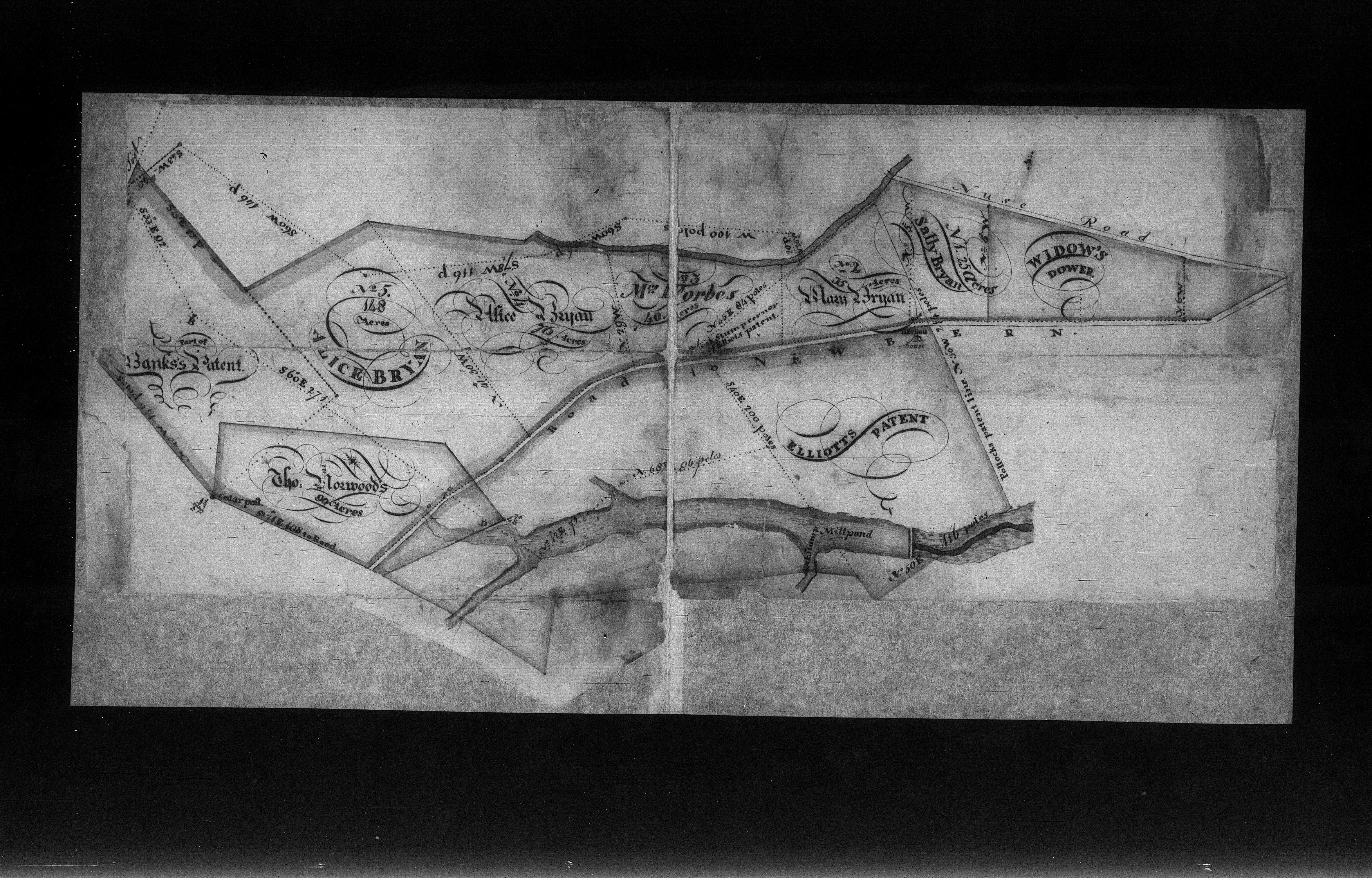
Map bemusement…
My friend Jennifer from California sent a deed over the interwebby air mails the other day… I’ll try to find it…
In the meantime, I got sidetracked looking at the 1770 map of Collet… his map artist had a very vivid imagination which attracted my attention… vizt:

You can zoom in at this link…
https://www.loc.gov/resource/g3900.ar150000/?r=0.538,0.336,0.484,0.374,0
Highlights…
Upper Right… note the Unicorn (which happens to be “chained” for some apparent reason which eludes me)… I thought Unicorns emitted pixey dust and flowery farts… who knew they were dangerous?
Lower left… note the Wildcat (which would commit suicide if it ever fully closed it’s mouth… it is plain to see the bottom teeth would protrude through it’s upper jaw…
Lower middle… note the scary water lizard…I’ve never seen this variety of alligator here in Florida… but to be fair to the artist, I don’t think they have them in England to sit for a painting…
Lower right… note the charming bikini clad, waving Indian… note also that he is balding… I can’t remember ever seeing a bald Indian…
Now I can’t find Jennifer’s pretty deed… the penmanship of this guy was amazing… perhaps she will send it back my way…
She found it… a thing to marvel…
Old Maps… where I get them
I try to get the oldest “base” maps I can find. There is a caveat to that however… I want “accurate” maps (meaning they are to an accurate scale). All that means simply is that I have ran across Civil War era maps of Virginia and North Carolina which date to the 1860s which show early areas… they are woefully inaccurate for what I do. The earliest maps that I have found can be found here:
https://ngmdb.usgs.gov/topoview/viewer/#4/40.01/-100.06
These are historic USGS topo maps. With certain limitations, I assume, they can be overlaid with modern satellite image maps (say Google Maps) and they hold up remarkably well. All of which sums up what I mean by my statement “the surveyed patents and deeds from the earliest colonial settlers are just as accurate now as when they were originally surveyed”. Let that soak in a moment. The measurements they took then are still accurate… even today. The difference is that they did not have accurate base maps to portray them at scale. The scale I use is one mile to one foot.
My major complaint is that they show railroads. Which are too damn NEW for my olde stuff. But then, at least they do not show Interstate Highways… smiling.
If you stumble across a modern map I am forced to use, it is because I cannot find an earlier version. I think in the past.
John White of Chowan…
A preliminary timeline…
In 1690 John White was granted an escheat patent formerly granted to James Welch. This was a Nansemond County patent. In 1704 John White was listed with 150 acres in the Nansemond Rent Roll along with his son George White with 50 acres. I am left to speculate that this land was located deep into what was North Carolina and likely Albemarle County. That County would later become known as Chowan “precinct”. I don’t say that lightly… I am basically shocked that I might speculate that a Virginia patent was issued what will be very far south. But then again… this was 1690. And I am not convinced that the Virginians did not actually consider that the the borderline was at Wiccacone Creek. Read the rantings of Phillip Ludwell…
In 1713 Simon Knight sold to John Welsh 80 acres “joining the River Pecoson [Chowan River] , Stumpy Creek, James Flemmins and a branch”.
In 1717 Peter Parker sold John Welch 260 acres on the River pocoson and James Flemons.
John White, in my opinion, adjoined these properties.
In 1717 John White Sr is listed in the Chowan County Early Census along with his sons John Jr and George and apparently another son or grandson named Luke. I have seen references to a son named Media
This image is simply for reference… don’t try to zoom in. This was 20 miles! south of the Virginia border.

Click the blue filename under the graphic to zoom in…
Some nitty gritty research notes…
My initial interest in this White colonist was ignited when I found a deed of sale for a “periauger” (boat) that was sold by one Media White to John Bryan. I simply wanted to find out where he lived.
Note this deed below… I’m pretty sure that Media White was a son of John White Sr and lived just across the Chowan River from where John Bryan lived on the East side of Chowan R. If you look closely on my map above and find (southery) the patent of Thomas Gilbert you will see he adjoined George White. This area was known as Rockahock Neck. That is where I think Media White lived.
I am overwhelmingly confident I have John White placed within spitting distance… his sons George and Media were, as I assume, in Rockahock Neck. That happens to be almost directly across Chowan River from where John Bryan lived along with Edward Bryan (who I assume was his father). All which makes it very convenient to make a deal on a boat. The possible “icing on the cake” to this speculation is that a place called “White Landing” is located on the River in the Rockyhock Neck riverside. What are the odds that one of the White folks had a landing there?
A headscratcher I cannot explain is to be found at this link… it seems that John White (along with Media White whose name stands out like a sore thumb) was granted 1200 acres for his headrights in 1701 in Bath County…
James Fleming d.bef 1722… Chowan “precinct”
I have no particular interest in this guy… no offense toward any folks who ARE interested in his history. I am, however, interested in WHERE he lived on the eastern side of Chowan River. His several patents dating from 1714 to 1719 all seem to have clues to a difficult area I am having trouble wrapping my head around. He is surrounded by numerous other folks who are on my radar for various reasons.
Vizt: Blind neck branch, Stumpy Creek, Bucky Swamp, Stopping Creek, Beechy Swamp, and lastly, an unnamed creek… all of which are referred to in concert with a creek going by the name of Indian Creek… or Old Town Indian Creek.
I am torn between two places on the eastern Chowan River… one just south of the Virginia/ North Carolina bounday just east of a place called Sarem. (see the post or two below this one)
Or… there is a known Indian Creek further down the Chowan River north of the town of Edenton and just across from a place I have mapped called Maul’s Haven (on the west side of Chowan River). Just slightly north of this creek is another named Stumpy Creek.
Each of these areas have peculiar attributes that attract my attention… and so goes my dilemma.
Perhaps one of you puzzle solvers can help me out? Here is the Fleming study… or my notes so far:
A simple question might be… was there an Indian Creek near Sarem?
This is the “official” Indian Creek.. the one nearer to Edenton
White,Copeland,Parker,Jordan,Fleming…Chowan/Nansemond
NOTE… I have changed my mind on where the general area of this patent group is located… it turns out to be about 15 miles further south… I leave these notes so you can see my thought process.
Below stems from my research on the NE side of Chowan River just below the Virginia boundary and NC. This area has befuddled me for years… but as in this case, once I get a good set of clues… the dam breaks.
See the Post below this one for some background…
The “general area”…
This has me waste deep in the tall grass… but most of my viewers realize that with my methods.
William Copeland’s patent is not placed because it is extremely complicated but once I break it down it should shed a lot of light on this area.
… as usual, click under the graphic on the blue filename below… a new window will open so you can use the ZOOM feature more effectively.
As the file above is not on my map… so below… This James Fleming guy and his land is difficult to map because I have yet to figure out the creeks and branches (they simply do not pop out on my base map…which is about a hundred years old) Like I say, once I figure it out this should answer many questions…
…an Update
If you look carefully at may map above, where I show the “general area” of the very early 1700s… note below on this modern Google map:
The interesting point to be made with my “speculation” of where these patents “might” be located is that in these examples: just underneath my graphic for John Jordan is a creek named JORDAN CREEK. Is this merely a coincidence? Likewise… I am trying to place 300 year old patents in this area for various PARKERS and I find a Parker cemetery dating to at least the mid 1800s and possibly earlier. Again, is this merely coincidence? Google Map for yourself to verify…
Oh… and note that the name of Jernigan Branch on modern maps is itself a reference to early Jernigan colonists. It seems that Jernigan replaced the name Jordan for reasons unknown to me. I have not traveled this area of the eastern Chowan River but it seems to me this is not a useless “swampy quagmire” but more of a wooded area “that may occasionally flood”. Anyone know?
https://www.findagrave.com/cemetery/2190393/parker-family-cemetery
chasing White, Bryan and Ballard shadows…
1729… John Bryan buys a “periague” from one Media White. This sale is duly witnessed by John White and Laurance Mague.
source: https://digital.ncdcr.gov/
So…to cut to the chase… I simply want to know where John White may have lived in 1729. Lawrence Mague was the purported father in law of John Bryan (Bryan married his daughter Alice Mague).
Common sense dictates that a periaguer (boat) would be near the water. But a periaguer was not a canoe… it was a somewhat larger craft usually also equipped with a sail.
As an aside… one Daniel McDaniel had a “periauger”. https://andersonnc.com/2021/07/09/daniel-mcdaniels-periauger/
Backing up a bit… who in hell would name someone “Media”? Well, John White did, evidently. You can search it out online… like I say, I just want to explore where Bryan and White and Mague may have found a convenient spot to make the deal for this freaking boat. Some folks think White may have settled near Bath County in the early 1700s. I don’t know… maybe/maybe not.
https://www.ourfamtree.org/browse.php/John-White/p38761
Here is where I think John White was in 1719… and why I think that.
as usual… click the blue filename below the graphic to open in a better window to zoom in.
Samuel Bozeman and John Ballard are just other shiny objects for you folks to fret over… I know how you are…
One Richard Parker left a whole heaping lot of lands to his kids in his will in Chowan “precinct”… I suspect he was the adjoining land owner to the John White land I discuss…
https://digital.ncdcr.gov/Documents/Detail/parker-richard-chowan-county/801684