Anthony’s Delight… a swamp that evidently excited Anthony
… in southeastern Virginia near the Nottoway River (more precisely just east of Nottoway SWAMP).
I found several deeds referencing it but am still researching other deeds to box it into its actual area… tedious stuff.


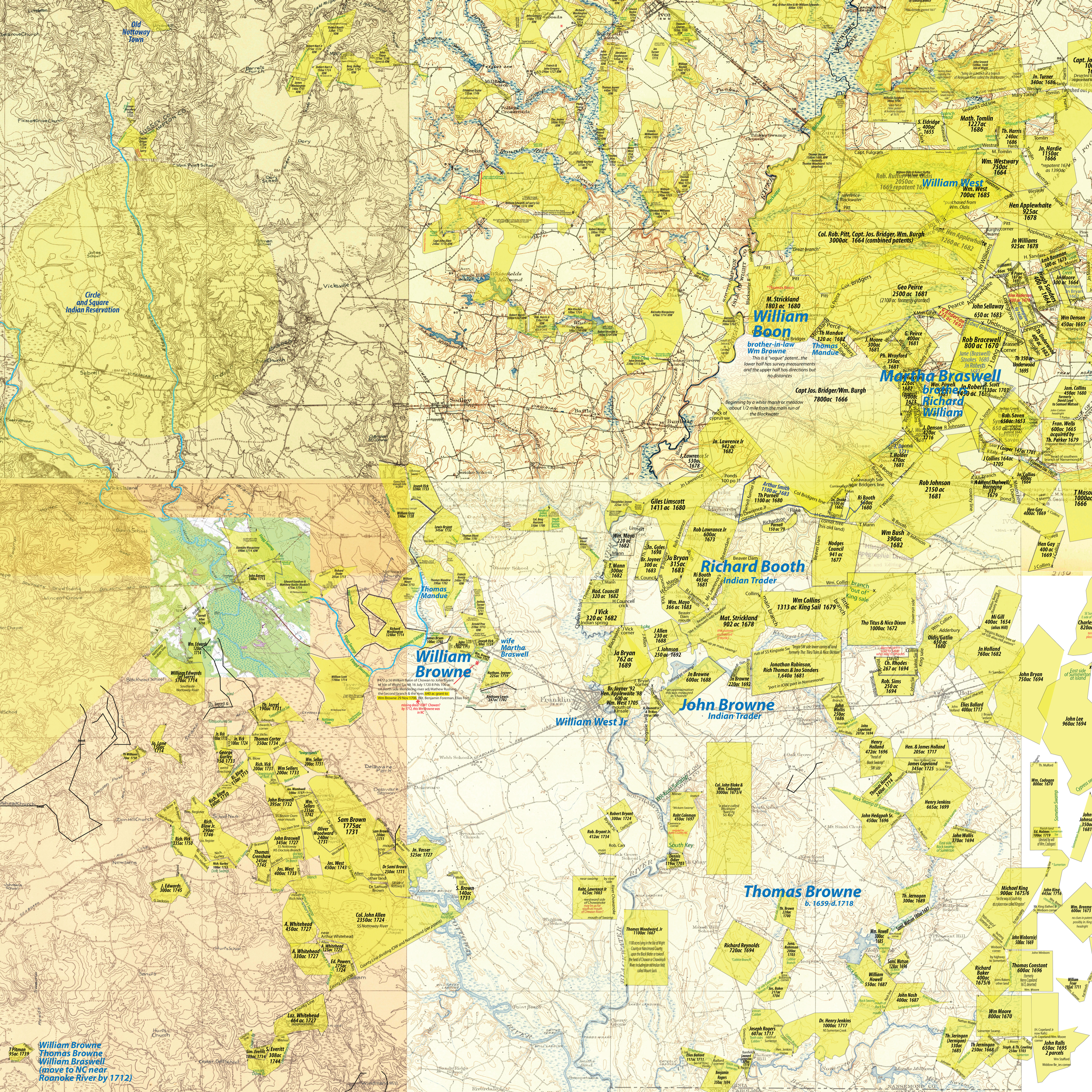
Here is the map…
 *Notes on Wm Brown…
Evidently he acquired 640 acres perhaps near his 1702 patent or more westerly near the MeherrinRiver (if anyone can cite the deed info I would appreciate it).
There are some mistakes online concerning Brown’e will…
Grimes abstract has Chowan county instead of Albemarle… no big deal but then he leaves out a son and other folks… I don’t trust Grimes, I’ve found too many mistakes such as this. Braswell researchers have mistakenly styled William Boon as “a brother”… that is clearly a mistake. The will reads thusly: “remaining land… to be Equaly devided between her and seven children excepting 100 acres to William Boon at other side mahe/ page cut off ( maherin?) River”. Now I’m not sure what the relationship was with Boon (if any). Browne may have simply owed Boon some money and settled it with his bequest? This info adds a bit of interest to my map above since Boon sold that 100 acres a within year after Wm Brown died. The old boy was barely cold.
Here is my abstract:
Will of William Browne 1718
Dec 1718… County of arbarmarll… sick and weak…
… to wife… bed, furniture, horse “toby”…
—-fold—– illegible
… fifty acres of Land belonging to yt (?) and my Riding horse “ball”… mare, cow, bed (etc)…
… son Thomas… 150 acres joining his brother John “Siprus gutt”… horse
… son Jacob… 150 acres… “Siprus gutt” joining brother Thomas… horse
… daughter Ann… 150 acres at “head of brother John”
… to John Carver… 50 acres at ye place where his father was kild… (The brother of the wife Martha was Richard Braswell who had illegitimate children by an Ann Carver/ coincidence?)
… daughter Martha… 150 acres… joining upon Carver
… dau Mary… 150 acres… between Martha and head Line…
… dau Sarah… 150 acres at ye ________? fort (what fort?… I’m beside myself with curiosity)
… remaining land… to be Equaly devided between her and seven children excepting 100 acres to William Boon at other side mahe/ page cut off ( maherin?) River (this does not say “a brother”; it says “at other)
… Thomas Mandeu & my wife executors
… I desire “my” son John to _____? with his mother… he is of age 19… likewise “her” son Thomas live with his mother til 19… likewise “her” son Jacob… likewise her daughter Ann til 18… likewise Martha til 18… Sarah …18
… son Thomas & Jacob a gun…
Wm Brown (signed with a signature and a mark… seemingly both his)
Thomas Mandeu (Mandue had property near Brown near Anthony’s Delight… Mandue originally lived near the Braswells in IOW proper…Mandue winds up living on Kirby’s Creek in NC about halfway between the Browne brothers; he knew them both… seems a lifetime friendship)
Thomas Smith
Martha (X) Brown (seems like wife since daughter Martha was underage?
abstract by Marc Anderson 2013
An online image of the will can be seen at NC Archives:
http://mars.archives.ncdcr.gov/BasicSearch.aspx
———–
An aside… In 1710 the obnoxious Philip Ludwell interviewed Richard Braswell concerning the boundary between VA & NC… Braswell “may” have been living near Wm. Browne.
The 22nd We went to the Nottoway Indian Town, where we had appointed Henry Wych to meet Us to give his Deposition, but he did not come. Here we took the Examinations of three Wyanoake Indian women that live here; having given them strict Charge to tell nothing but the truth. But the Nottoway Indian old men being gone to gather Chinkopens We deferred the taking their Examinacons till our Return, and went to the Nansemond or Potchiak Indians Town. In our Way thither we mett one Richard Bratwell who told us that he had entered for about 1000 acres of land with Mr Moseley and had it surveyed upon Maherine River, being persuaded to it by the sd Moseley, who assured him it was in the Carolina Government and that Nottoway River was Wyanoake and he pretended to read a copy of the Carolina Charter which express’d that they were to begin at the North end of Carotuck Inlett, & to go to Weyanoake River or Creek being in 36 1/2 Deg Lat; & that Mr Moseley did take the Latitude of Nottoway River’s mouth, & told him & others then present that it agreed, and from thence he run a due West Course to Maharine River, and we afterwards had ye same accot from others. But Mr Moseley on our asking him, denyed that he had ever tried the lattitude of Nottoway River, tho’ he owned he had run a line from the mouth of it due West to Maharine River, wch he did by order of their Council.
The 23rd. We took the Examinacons of Great Peter the Nansemond Indian after his Examination he told us, that sometime before, he was sent for to Coll: Pollocks, where were Governor Hyde, Mr Lawson, Coll: Pollock & others, they examined him concerning the Wyanoake Indians and Weyanoke Creek that he gave them the same relation he has given us, and that thereupon Coll. Pollock was angry with him & said, such storys would do the Proprietors a mischief; he answered that he did not come of himself to tell any storys, but was sent for, & if he desired to hear it, he would tell him the truth, but if that would not please him he would not tell him a lye. That Mr Hyde said he was in the right, he said Coll. Pollock urged him very much to drink, but he thought they had a design upon him & would not.
Then we proceeded to the Maherine Indian Town and took their Examinacon. At this place there was one John Beverley, who reckons himself an inhabitant of Carolina, whom we desired to take notice of the manner of our proceeding in taking the Examinations and of the questions asked them. This man had been all up Wicocon Creek & had taken up some land in the Fork of the Creek where the Weyanoake Town stood and when we made the Indians mark out upon the ground, the Creek & Swamps, & the places where the Weyanoake Indians had Corn fields he confessed the Creek Swamps & old fields were as they described them.
The 24th we set out for Mr Moseley’s.
The full account is here:
Browne evidently had quite a bit of property in the area…
(p.29) 20 Oct 1716…. William Brown, Yeoman, and wife, Martha Brown, of Chowan Parish in Albemarle County in North Carolina to Anthony Lewis, Sr., Yeoman, of the lower parish of Isle of Wight… 366 acres in two surveys (being all of two patents except 50 acres) in the lower parish on the south side of the main Blackwater at a Branch called “Anthonys Delight”. 106 acres was granted to said William Brown on 28 Oct 1702 and 260 acres was granted him on 16 Jun 1714. 50 acres has already been sold by said Brown to Henry Applewhaite.
Wit: William (X) Hukman and Thomas (X) Lush.
William Brown
interesting that both of these deeds refer to Browne as “of Chowan Precinct/Parish” and not “lower parish of isle of Wight”
#412 pg. 201 WILLIAM BROWNE of Chowan Prect., planter and MARTHA his wife to MATTHEW RUSHEN of the sd. Prect., planter 21 Apr. 17– 8 L. 150 acres on ye west side of Meherrin river, joining Dividing Run and ye River part of 640 acres surveyed by ye aforsd. BROWN Wit., GEORGE SMITH, JOHN SMITH Reg. 2 Feb. 1714/15
———————
Brother Thomas (my assumption is brother from circumstantial evidence… no hard proof yet) lived near the Chowan River at his death… I have mistakenly assumed for years he lived near the Roanoke River near William Browne…. his will clearly shows otherwise:
Will of Thomas Brown 1718
April 1718… Albermar County… sick & weak
… to Christian… my wife… plantation whereon I now live beginning at the corner tree above the inden parth so running down the Line to potocati Creeke and so including six hunderd ackers of Land and Like wise six hunderd ackers of Litwood Land for the use of the sd plantation and for the maintanance of his children beginning? at Thomas Conners corner tree and Line and so running to bells branch and so up ye sd…
—-fold—- illegible
… wife c all my moveabel estate within and withoute untell hirr children come of age or marries then if can be spend_______? to have to cowes and calfs a peace Except my son Thomas brown when he is of age or maners? marries? the to him three cowes and calfs if they can be spard
and my dafter Sarah mackdaniel I give unto her twenty shilings
and every one of my children _______? or ______? as they come of age if (any?)(they?) can be spend
… unto son Thomas… to hunderd eakers and twenty eakers of land being and lying upon potacati Creeke
… son William the half of the upper sirveys beginning at the ____? tree swamp
… son Thomas… other half of ye sd sirveye
… son John and Edward Brown my Land that Lies on ye South side of meharin Creeke and (land that is left of the Land that I sould to George Stevins)
… son Howell and James… the sd plantation and all the land belonging after my wifes deses…
Thomas (X) Brown
Judeth (X) Perry
Thomas (X) Perry
abstract by Marc Anderson 2013
This area seems to be Potocasi Creek near where it meets the Meherrin River and Chowan River.
—————-
The “litwood” reference in Thomas Brown’s will probably hints that he was manufacturing Turpentine and Tar & Pitch…
As early as 1717, Virginia passed a law stating that anyone manufacturing naval stores from crown lands
for which they had no intention to patent and pay quitrents would be guilty of trespass. The problem
arose in North carolina as well, especially after 1730, when small producers, who owned little land, began
production in the Albemarle area. Tapping the pines: the naval stores industry in the American South
By Robert B. Outland p. 33
This is perhaps why many left the area…
As North Carolina followed the rule and method of the adjoyning Colony of Virginia by settleing ye Quit Rents of Lands therein to be paid at 2s for each hundred acres (which does not exceed 4d English money) it’s reasonable to believe that if such Quitt Rents are advanced so as to exceed the rates paid in Virginia, the Inhabitants must of course judge themselves rather oppressed than relieved, which will deterr them from cultivating an increase of Lands, when they must be more expensively obteyned than by their Neighbours, which will certainly prevent them from engaging as they flattered themselves to doe, on the Province becomeing the property of the British Crown.
Which should certainly be avoyded for that North Carolina has vast tracts of Land not improveable by the Power of man some part thereof being Pine barren Land which can never redound to the least advantage of the Owners (except once in 20. or 30. years) when they gather there from a small quantity of light wood to make pitch and tarr, and many vast tracts there are very low and exceeding wett, in soe much that noe place thereon can be found to raise the least structure to dwell in, and attended with the great illconvenience of the overflux of the Rivers almost thro’ out the Country, which terryfy all from any attempt of seetleing there which occasions a just fear of perishing by water and that in some places even for 30 miles together, as particularly on Roanoak River and soe in generall tho’ in different degrees.
http://docsouth.unc.edu/csr/index.html/document/csr03-0041
This probably accounts for the short ownership of properties and then the folks move on… these guys weren’t dummies… it also helps me to understand the “lapsed” patents which frequently show up in the records…
This is perhaps the other 600 ackers Thomas Brown left in his will… “and Like wise six hunderd ackers of Litwood Land for the use of the sd plantation and for the maintanance of his children”
Minutes of the North Carolina Governor’s Council
North Carolina. Council
April 02, 1724 – April 17, 1724
Read the Petition of William Brown Shewing that some time agoe —— Browne Senr took up and patented a tract of Land lying on the old Tree Swamp which is not Cultivated as the Law directs prays a Lapse for the same &c
Ordered That a Patent Issue as prayed for
uh hum… plus the tobacco of course…
Deed Book B #1, Chowan Co., NC
#1184 pg. 644 CHRISTIAN BROWN of Albemarle Co., widow to JOHN ROGERS (residence not given) 21 8ber 1718
for 1000 pounds of good Merchantable Tobacco 118 acres more or less, joining ye River pocoson and WILLIAM BROWN
Wit: (not given) Reg. 27 Feb. 1718
Leave a Reply