a note on my maps…
I’ve been plastering this little snippet of my Surry/IOW map on pages a lot lately… aside from the Historical aspect, it shows a bit of technical wizardry…note the green area that is highlighted:
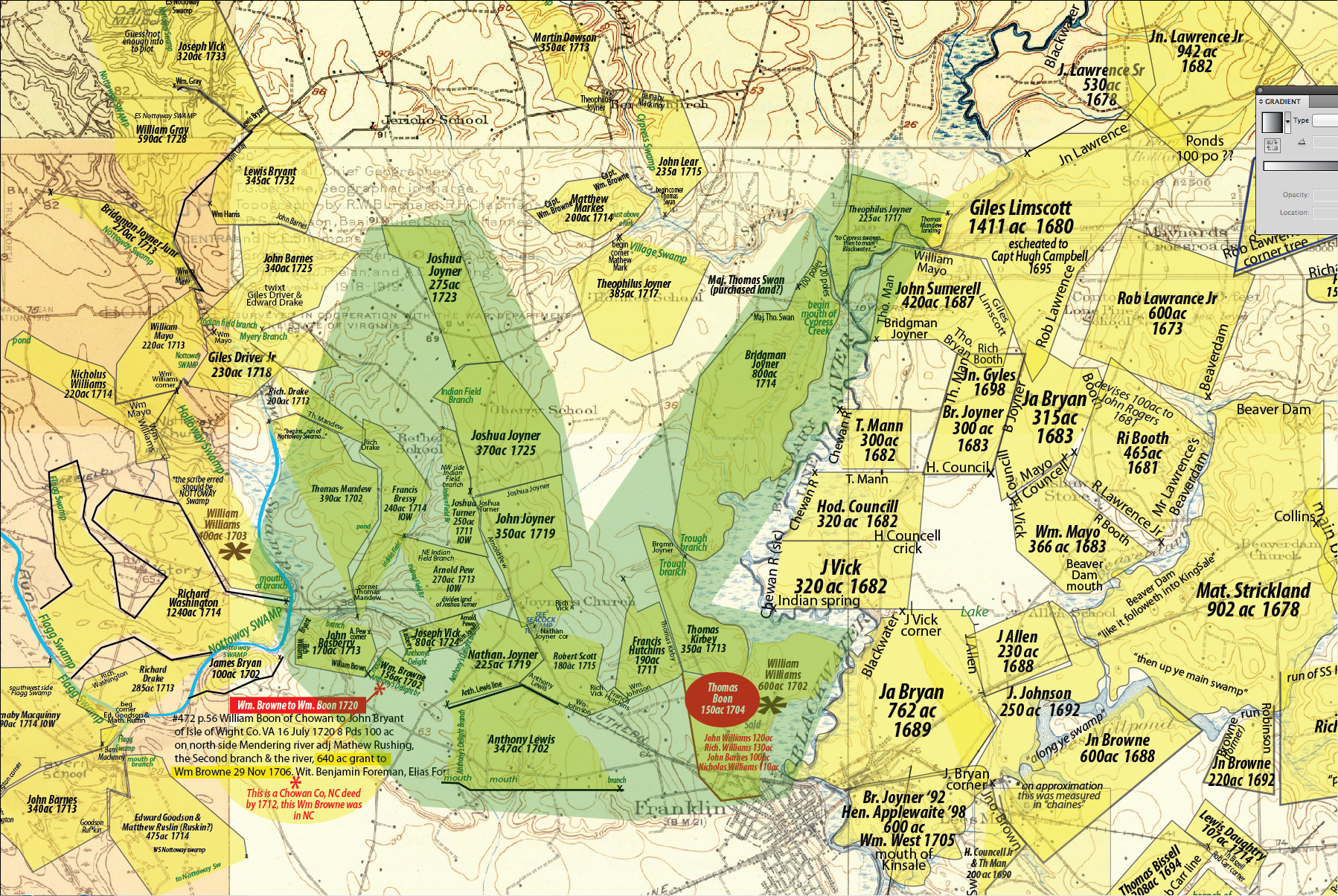
I grab the original Patent info from the Library of Virginia and redraw it into a “Jig Saw piece”… you can’t twist it or turn it… it either fits with a neighbor or it doesn’t… period. You just can’t “force” it to fit. I just marvel at how tight this little section is.
The majority of these surveys “close”… which is a testament in itself to the old guys and their hard work and accuracy.
Just discovered your site and amazing work! Really appreciate the detailed work. What graphic program are you using to edit your maps? I’m looking to do something similar for an unrelated area.
Rob
August 23, 2014 at 12:56 pm
I use Adobe Illustrator for the graphics… then compose it all in Photoshop and save it as a JPG.
anderson1951
August 24, 2014 at 5:53 am
This map is incredible. I found it because I’m researching an Andrew Griffin from the area and began seeing references to his land once belonging to a “Barnaby McKinnie”. Is the green section part of patent of 3,435? Also could you help me find on your map the land that belonged to either Henry Pope or Andrew griffin? It should be adjacent to John Joyner’s land that was sold to him by Jones and Rebecca Griffin in 1760. Here is the deed description: JOHN JOYNER dated 11 Dec 1760
300 acres on the south side of the main Blackwater Swamp adj. Mill Pond and
old survey between HENRY POPE and ANDREW GRIFFIN. Thanks.
Jeremy
January 29, 2015 at 1:31 pm
With few exceptions… all of these are original patents (from the Library of Virginia).
That is where I get the metes and bounds to plot the patent.
In other words… you will have to find where your guy would later show up from the clues.
https://andersonnc.wordpress.com/some-surryiow-patents/
The green area is just a “highlight” I fabricated to make a point… it has nothing to do with any patents…
anderson1951
January 29, 2015 at 3:22 pm
I took a look at the Metes and Bounds program. You can manually spin a parcel. For example, if you want to spin clockwise 5 degrees, add 5 degrees to all NE & SW bearings and subtract 5 degrees from all NW & SE bearings. Counter-clockwise, reverse. Subtract 5 degrees from all NE & SW bearings and add 5 degrees to all NW & SE bearings.
Besides surveyor errors, magnetic north changes slightly every year. A magnetic north reading in 1650 will be about 6 degrees west of a magnetic north reading taken in 1750. So a 1650 survey would have to be rotated clockwise about 6 degrees to match and fit to a 1750 survey, assuming no other errors. Conversely, turn the 1750 survey counter-clockwise, if fitting to the 1650 survey. The 6 degrees magnetic declination stated is specific to the IOW area. Per year is roughly 3.6 minutes change. Colonial surveyors were expected to use a tedious mathematical calculation called double meridian distance method to balance and correct errors. If errors were on the high side, when balancing was applied, it was applied to all bearings to share the error, inducing a potentially significant error to previously good bearings.In other words, don’t be surprised if a perfect match doesn’t happen.
Btw, I have 30 years experience in cadastral mapping(using land surveys). Recently retired and will be working on a similar project in the Pee Dee area of north east South Carolina. I descend from Gideon Gibson, who settled there. I have DNA matches for Gibson, Anderson, Baker, Ballard, Gray, Dillard, Brown, Lewis, Ray, Holland, and others from IOW, Surry, Chowan, Gates, and Pitt counties.
Jeff
June 22, 2016 at 12:06 am
Thanks for the info Jeff…
Good luck on the Pee Dee project… it is relatively easy with my Virginia patents as they are all documented and easy to find. My looks into North and South Carolina have been, shall we say, “irritating”.
Check out my Civil War map. It may be a method to “crudely” map some of these Carolina properties. I welcome any advise.
https://andersonnc.wordpress.com/roanoke-r-to-chowan-1863-civil-war-map/
anderson1951
June 22, 2016 at 4:40 am
Jeff
What to do if a direction entry is backwards?
such as E 32 S 320 (poles) ???
My software only offers a N or S begin point to plot.
Marc
anderson1951
July 18, 2016 at 3:19 am
If you only have one bearing that is not conventional, then ignore it and do all others until that bearing only remains. Then close back to beginning. You should be able to tell if it is 32 degrees east of south or if it is 32 degrees south of east. If you have more than one bearing out of convention then that will not work. If it is intended to be 32 degrees south of an initial east bearing, then that should equate to a S 58 E bearing. You may have to try that to reach closure. Measurements are Chain = 66ft , Pole = quarter chain or 16.5ft , Links = 100th of a chain or 7.92inches. A 66ft surveyors chain is composed of 100 links.
Jeff
July 18, 2016 at 9:47 am
The S 58 E is what I tried and it seemed to work… but then the next bearing was conventional.
Here is the patent (Lewis Williams). The open section (Chowan River) has to be on the right of the patent… so that is something of a clue.
http://www.nclandgrants.com:8081/grant/?mars=12.14.46.39&qid=169613&rn=1
anderson1951
July 18, 2016 at 11:27 am
Returning to convention is good just continue. You may occasionally need to “reverse” a bearing i.e…you need to head NE (say to reach a stated river or road that is obviously NE) but the bearing states SW, just swap the bearing quadrants to correct a known error. Sometimes around impassable terrain a surveyor will survey to a temporary point to reach good terrain, they will sometimes backsight to a previous good point and write the reversed backsight into their notes and forget to correct the direction when drawing the survey to scale. Also its a common problem when grants are subdivided. Original boundary bearing is retained despite a reverse bearing being needed for the individual new lot. I cannot access to plat from mobile, will look we I can get a visual on it.
Jeff
July 18, 2016 at 5:49 pm
Jeff
Thanks for hanging in for my questions… I will post a new map in a day or two. In composing the base map I am blown away by the information that is available. My friend David Gammon (the author and genealogist from NC) once said to me … (paraphrasing) “Man..we are dealing with history here”… so true.
Here is a tease…
Source: http://www.hpo.ncdcr.gov/nr/HF0388.pd
The rural area in which Harrellsville is encompassed, four miles west of the Chowan River,
has been constantly traveled and inhabited._ by settlers since Ralph Larie’ s discovery ·of
the Chowanoke Indian community at the site of present-day Mount Pleasant in 1586.
In 1663, Sir William Berkeley, then the Royal Governor of Virginia, made a land grant to
the first Surveyor- . General of North Carolina, Thomas Woodward; Woodward’s 2,000
acres ·from the Virginia colony was sited on the west side of the Chowan, beginning
“fifty poles below a small is at the lower point of the old. ·Indian Towne [site of
Mount Pleasant], running west-southwest (Parramore MS, Chapter Two).”
In 1701, Woodward’s heirs sold the “Woodward’s·creek” property to Lewis Williams;
who had moved south from Nansemond County,· Virginia, ten years before.
(Parramore MS, Chapter Two) Because of the Tuscarora and Meherrin Native American
communities, white settlement did not take hold until the 1720s when the Wynns,
Sharps, Downings and Sumners began to colonize the lower Wiccacon area, which
was then a part of tne newly-formed Bertie County.
Note that the deed I am questioning you about is the “Lewis Williams” deed… he had several which I am trying to nail down.
Good fun my friend….
Oh… if you are not familiar with Dr. Parramore (PhD) … it is worth a Google search…
anderson1951
July 18, 2016 at 6:52 pm